Travel Date 5th-7th April 2010.
Please click on any picture to see the larger version.
This is a long one. Grab a cuppa and settle back and relax for a while.
The ruins, of course, are fascinating; for those I will let the pictures tell the story once again with just a few explanations at the end.
In my own case, the uncertainties of the journey to and from Machu Picchu were almost as interesting. That is using the word in the sense of the Chinese curse “may you live in interesting times”. I probably should have titled this “the journey to Machu Picchu”.
Last January I was thrilled when I managed to book return tickets on the Vistadome train from Poroy (near Cusco) to Aguas Calientes (now re-named Machu Picchu Pueblo; I'll use both names) which is the tiny tourist village below the site which can only be reached by train or the old pedestrian Inca trails. The return leg had been booked out and after many tries on the internet I eventually secured a seat after somebody cancelled. I also booked a private room for two nights at a hostel.
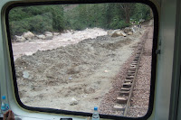
One week later torrential rains washed significant portions of the track away. Aguas Calientes, and consequently Machu Picchu, was now isolated. The Inca sites and trails were closed and Peru was suffering from a major calamity at it's primary tourism income earner. The affect on the local communities was disastrous; not only from the loss of lives and jobs but from the flow-on economic effects. Worse than that it affected all of the tourist centres on the “Gringo Trail” that I have just followed: Nazca, Arequipa, Colca Canyon and Lake Titicaca. If Machu Picchu is closed, the tourists dwindle to a trickle for the entire country of Peru.
My problems were trivial compared to theirs, but were still significant to me, as Machu Picchu was one of the major reasons for my decision to visit South America. I had to review whether I should drastically change my itinerary, with almost all my pre-bookings already made, or, more drastically, whether it would be wiser to cancel completely and consider going next year. Many of my bookings were non-refundable although travel insurance may have covered some.
I did some more research and decided to continue with the same itinerary I had first planned. I decided that if Machu Picchu was not available when I was planning to go on the 5th of April I would spend the time in similar, but less spectacular, sites near Ollantaytambo, a village about half-way between Cusco and Machu Picchu.
The Peru government eventually announced that sufficient track repairs would be completed to allow Machu Picchu to re-open on Apri1 1st. April Fool's Day. So I was cutting it very fine. Perurail offered me a refund, but I decided to let my booking stand because I realised that if the track was repaired in time there would be an over-subscription and I hoped that would give me some priority. That was a wise decision as it turned out.
I joined several others with similar concerns on the Lonely Planet Thorntree thread which kept us all informed of progress. To cut a long story short, a critical section of the track between Piscacucho (the 82km from Cusco point) and Machu Picchu Pueblo was finished and tested carrying trains on March 29th. After further testing the Park and the Inca Trail were re-opened on 1st April. The only trains able to use this section were those that had been on it at the time of the disaster. These were the two-car and four-car Autovagons. A more traditional train was able to service the villages further up-line but I suspect it is too heavy for the quickly repaired track.


I was able to convert my booked tickets to a combined bus/rail ticket. The bus went from Cusco to Piscacucho and the train went from there to Aguas Calientes. Coming back I decided to modify that to a different time which meant that I changed buses in Ollantaytambo. The buses were actually micro-buses, carrying 10-15 passengers; anything bigger could not have travelled on the very, very poor road between Ollantaytambo and Piscacucho. The entire trip, to travel about 120-130 km (75-80 miles) each way, took about two hours in the buses plus 90 minutes in the train.


I made it! That was when I found that my hostel was at the very top of a long, steep hill and the only form of transport within the town is your own feet.
However, getting there was only part of the fun. Once there, I needed a ticket to enter the site. During that first week of operation there was enormous uncertainty in Cusco - and online - about where and when those could be bought and how many would be released. After being directed by three different very cheerful and totally useless police to three different wrong addresses I eventually found the ticket office in Cusco behind an anonymous green door on the Thursday prior at 1:30 pm. But it had closed at lunch-time that day for Easter; before Monday it would only be open for a few hours on Saturday morning. That seemed a careless way for the Peru Government to handle the situation considering the circumstances. However, I was near the front of the queue when it opened on Saturday. When I arrived in Machu Picchu Pueblo I found that they had also opened the ticket office there; they just did not bother to announce it to the tourist public.


From the village it takes another half-hour or so in a bus; first alongside the still-raging Urubamba River then up the side of the mountain on a hair-raising (if I had any – instead I closed my eyes at times) dirt road that is a continuous set of hair-pin bends with spectacular (another word would be terrifying...) views in the short spaces between them until you reach the entrance.


Well, I made it. Was it worth the trouble? You bet it was. After staying overnight in the village I arrived in the morning mist about 10 am; the mist gradually lifted and the magnificent terraces of Machu Picchu slowly came more clearly into view.


Stunning.


One can only imagine how Hiram Bingham felt back in 1911, when he stumbled across Machu Picchu while looking for a different city, Vilcabamba. The Quechuan name means “Old Mountain” but Bingham called it the “Lost City of the Incas”.


In a sense he was right – the Spanish and their successors in Peru had no knowledge of the place at all. Just a few locals, including the one Bingham met who led him to the site. At the time they found two Quechuan farming families occupying it; blithely unaware of it's importance.


It was mostly covered by jungle at that time but he quickly organised funds from Yale University and the National Geographic magazine to clear the site and commence archaeological research. Many years later the Peruvian Government took over responsibility for conservation of the site.


I call them ruins; that is accurate but a trifle unfair. They are remarkably stable, complete and undamaged for structures that are built near the tops of mountains in a region known for it's earthquakes and fierce weather, as evidenced in the mud-slides that have just wiped away the rail lines and parts of towns. That weather hardly affected the ancient parts of the site. Among other things the Inca's subjects were superb masons and marvellous hydraulic engineers.


The important sections of buildings are built by stones so carefully shaped that they fit together perfectly and almost immovably without mortar. A form of mortar was used to extend above those structures in the less important sections.


The architecture was brilliant for its time, and at least equal to many parts of Europe in the same era – especially when you look at some of the stone houses for the workers and peasants.


Wood was rarely used for structural purposes but was reserved for things like doors, flooring (for the second floors) or similar support functions. Roofs were thatched; rather sensible in an earthquake region.
The hydraulic system is awe-inspiring in several ways. The terraces were designed on the slopes to retain the water they needed for agriculture and at the same time slow down and regulate the flow when torrential rains occurred. Being well above the river, water had to be directed to the top of the site by aqueducts from higher springs during dry times. Throughout the site there is a system of channels carved in the rock, with fountains and storage for water as it flows down the slopes.


These “Indians” were not primitive in those aspects of technology at the time the Spanish arrived. Sadly, they were pretty primitive in other ways that allowed the Spanish to take over with such small forces. But that's another story.


Note the organic lawn-mower at work. Apparently llamas are not usually found in this district, these were brought in for the task.
No-one is quite sure why the city was abandoned but the story is that when the Spanish came as close as Ollantaytambo the Inca abandoned the city to be certain they would not find it.
The guide and my research say that the city was built over just a few decades from 1460 to 1470. I don't believe it. This city had to take longer to build than that. They also estimate that its population was only 1200 and that it was supported by the seven Inca trails that lead to it through the mountains. I cannot believe that it appeared, and disappeared, so quickly. This city needed thousands of workers to build it, if not to support it, and that had to happen over centuries. But that's just my opinion, I'm no archaeologist.


Cheers, Alan

Hi Alan -
ReplyDeleteScott Patton here, we met in a small cafe on the way up to see Colca Canyon outside of Arequipa, Peru. You told me all about the Nazca lines tour you took. It looks like we were at Machu Pichu at the same time as well. I think my favorite part was watching the place come out of the fog and just imagining the complexity of the society that they had there. Great blog. Happy travels
I am considering going to MP in the first week of March. However the threat of rains during this time seems pretty high. Does it even make sense to go to Peru and MP during this time?
ReplyDelete